Purpose and legislation
Geospatial Litter Analysis (GLÂN) has been designed as a litter monitoring methodology for the purpose of gathering data for Extended Producer Responsibility (EPR) litter payments, a Deposit Return Scheme (DRS) and other litter-related policy, as well as for monitoring cleanliness levels across local authorities.
Cleanliness will be measured in accordance with the revised Code of Practice for Litter and Refuse (COPLAR) which relates to Part IV of the Environmental Protection Act 1990.
Sampling
As an upgrade from the Local Environmental Audit and Management System (LEAMS) methodology used between 2007-2024, the GLÂN methodology is carried out on publicly accessible parks, bathing water sites, car parks, streets and transport stations, and considers areas such as green and open spaces, verges and pathways. These have been identified through Ordnance Survey (OS) geospatial data and are categorised by Keep Wales Tidy according to land use under the labels of transport, recreation, commercial, residential or bathing water.
For each local authority in Wales, a statistically significant sample of sites (at a 90% confidence level) are surveyed each year. This sample comes from a large pool of potential sites. Each year, the sites to be surveyed are spread across 20% of the total Lower Super Output Areas (LSOAs) in each local authority, which are selected through an even split of the overall deprivation groupings from the Welsh Index of Multiple Deprivation (WIMD).
This means that the results are representative of each local authority overall every year, and after five years, every LSOA in every local authority will have been surveyed, creating a complete picture of the issues on the ground.
Within each LSOA, surveyors select a “cluster” of sites to survey with a good representation of the land use types within, prioritising non-residential sites to maximise data collection of the less common land uses where present.
How sites are surveyed
One survey is conducted at each site and often naturally covers areas of higher footfall around the entrances to streets, parks and other sites. Each survey consists of an approximate 50 x 10 metre survey area which is surveyed by walking both ‘sides’ of the 50 metre length to cover the whole area. The 10 metre width is based on the average width of a street and used to standardise the survey area across different land types.
Items seen outside (but a reasonable distance from) the 50 x 10 metre area are also counted as they would also influence the public’s perception of the cleanliness of a site. However, litter data is only collected from publicly accessible land i.e. it will not include private gardens or areas with paid entrance.
Collecting data
Around 75 litter items or groups are identified and counted during the survey.
The number of litter items or groups counted each year may change, based on additions or removals of emerging or recurring issues as appropriate. Items include, but are not limited to, drinks receptacles, food packaging, cigarette butts or other smoking-related items, household items or hazardous items.
For more information on the litter items or groups counted in GLÂN each year, contact leq@keepwalestidy.cymru.
The street scene data is made up of eight Adverse Environmental Quality Indicators (AEQIs), which are designed to portray that “a clean space is more than just an absence of litter”. These are public infrastructure, graffiti, fly-posting, vandalism, weeds, detritus, dog fouling and fly-tipping.
Each AEQI is scored based on its condition as either absent, pass, attention or action. The condition for dog fouling is automatically calculated based on counts of bagged and unbagged dog fouling, but the remaining AEQIs are scored by surveyors based on the condition descriptions and criteria. If any AEQIs are interpreted as being malicious or hazardous, an “action” condition for that AEQI will be selected.
How sites are graded
To present the cleanliness of sites consistently, each site is given a litter and dog fouling grade.
Each litter item or group is given a weighting based on a combination of size and impact. Most items are weighted at 0.1, 0.2, 0.5 or 1, however, items or groups that are likely to have a bigger impact (such as dog fouling, syringes and other hazards) have been weighted higher.
[Count of items] x [Weighting of item] = Score per item
[Sum of all individual scores] = Litter and dog fouling score
Litter and dog fouling score = Grade
To calculate the litter and dog fouling grade, the weighting is multiplied by the count of the litter item or group to give a score per item or group. These individual scores are summed to give the litter and dog fouling score for the site. The litter and dog fouling score translates directly into a grade, and each grade is accompanied by a descriptor of the level of action required by a local authority or landowner.
If you require the table below in any other format, please contact leq@keepwalestidy.cymru.
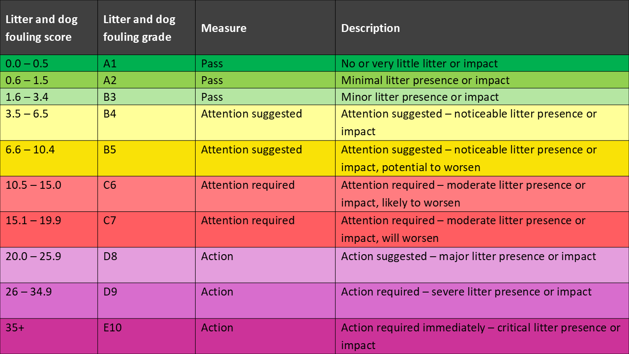
To represent the overall feel of a site in a precise and easily understandable way, each site is assigned a ‘street scene’ grade.
To calculate the grade, each AEQI and their conditions have been assigned a score based on the severity of its impact. Therefore, more impactful AEQIs have higher score e.g. vandalism and graffiti. The scores associated with the condition of each AEQI for a site are summed together to create the street scene score.
[Sum of individual AEQI scores] = street scene score
Street scene score = Grade
If you require the table below in any other format, please contact leq@keepwalestidy.cymru.
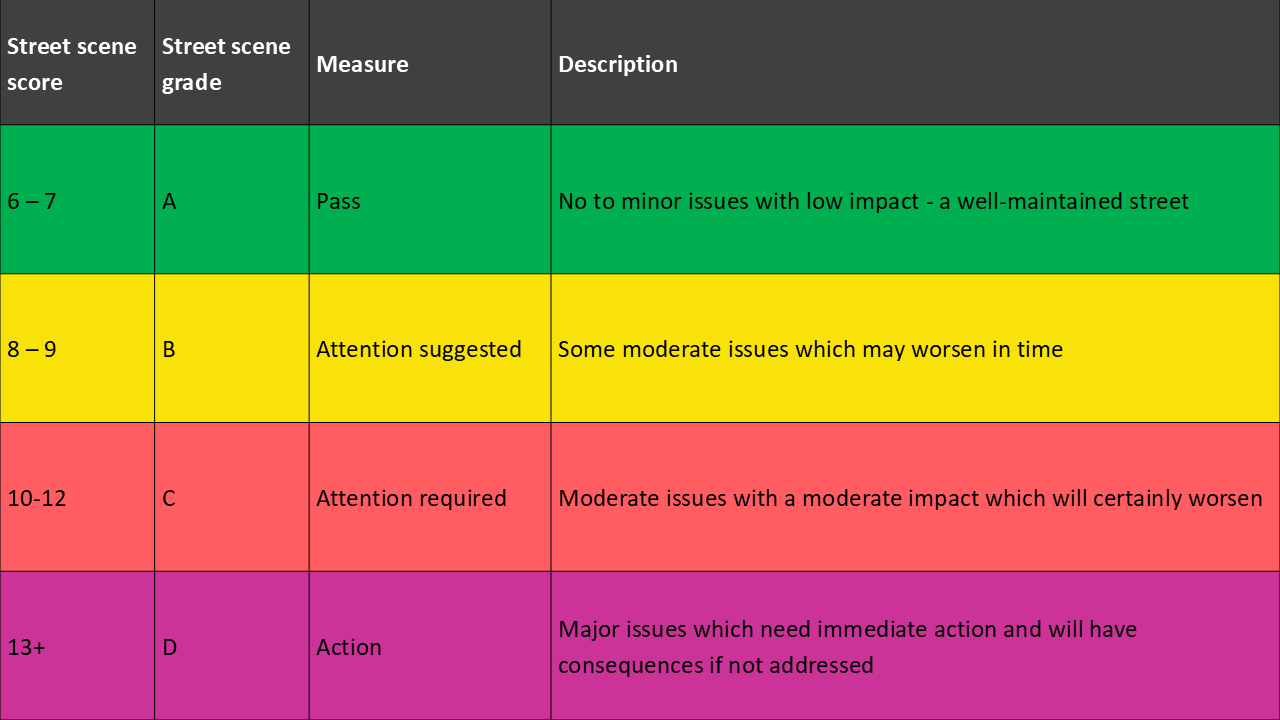
Performance indicators
Performance indicators will be used to show how local authorities are performing in relation to a designated standard. Regulatory standards have been reduced or removed and related regulations and guidance have not yet been replaced but are currently being considered. In the meanwhile, Keep Wales Tidy has engaged with local authorities to create temporary performance indicators:
Litter and dog fouling – Percentage of sites graded A1 to B5
Street scene – Percentage of sites graded A and B
More information
For more information on the GLÂN litter monitoring methodology, please contact the Policy and Research Team.